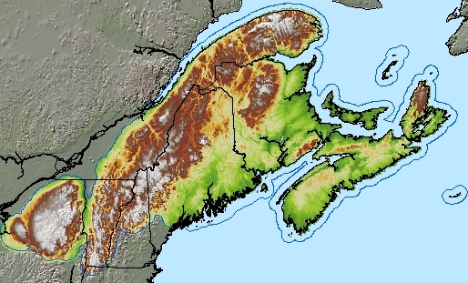
Where the Appalachians - North America’s second-largest mountain chain - cross the international border between the northeastern United States and eastern Canada, boreal and deciduous forests meet to produce high levels of biodiversity. This region also has one of the longest histories of intensive human settlement in North America. Ensuring the conservation of biodiversity and ecological integrity of this ecoregion is a challenge requiring landscape-scale planning and transboundary collaboration.
Larger Image
With it's complex transboundary geography the Northern Appalchian Ecoregion encompasses all or part of 4 Canadian provinces and 5 U.S. States. It extends from New York to Nova Scotia, including the Tug Hill Plateau and Adirondack mountains of New York, the Green Mountains of Vermont, the White Mountains of New Hampshire, the north woods of Maine, the Gaspé peninsula of Quebec and all of Maritime Canada
 Transboundary Conservation Planning
Achieving transboundary conservation planning requires the collaboration of organizations from across the ecoregion. By bringing together science that identifies important ecological features for conservation and connectivity with maps of accumulated human impacts on the landscape - the Human Footprint– a common conservation vision for the Northern Appalachians can be found. To find out more click here.
 Eastern Small Carnivore Initiative
Mid-sized carnivores (mesocarnivores), like the Canada lynx and American marten, are the new top predators in the Northern Appalachians since the disappearance of wolves and mountain lions. Ensuring for their conservation in the face of changing climate and forest conditions requires coordinated planning and research among regional biologists, managers and conservation practitioners. To find out more click here.
WCS in the Adirondacks
In the mid 1990's, WCS established the Adirondack Communities and Conservation Program in response to a need for an information-based, cooperative approach to research, community involvement, and outreach. The Adirondack program has since evolved to encompass several interrelated projects that work to promote healthy human communities and conservation in the Park, with a guiding philosophy that these are compatible goals. To find out more click here.

With generous support from The Printing House (TPH), WCS Canada will work to save wildlife and wild places across Canada. TPH is supporting our Conservation Mapping program which uses GIS (Geographic Information System) mapping technologies to provide information and analysis opportunities to support our wildlife conservation projects.