In spite of the large area the Amazon biome spans in Brazil, the growing impact of economic activities in the region has been increasingly threatening forest integrity. Opening up highways is the main factor driving habitat loss in the Amazon.
Even when forest cover on the areas along the highways is relatively good, there is no estimate of the amount of change caused by selective logging and hunting, since remote sensing techniques are not capable of detecting their effects.
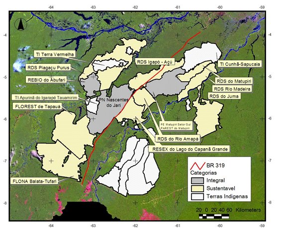
Considering the Amazonian context and the imminent repaving of BR-319, the highway that connects Manaus to Porto Velho, it becomes crucial to understand the natural fluctuations of populations, their densities and spatial distributions before the impact.
This is the only way to gauge whether the changes brought about by the intervention lie outside the expected natural variation, measured in the absence of impact. In other words, this initial condition should be the starting point for any monitoring program.
Conservation Challenges
In view of the current Amazonian context and the imminent reconstruction of BR-319, with resources already allocated to the Growth Acceleration Plan (in Portuguese, Plano de Aceleração do Crescimento, PAC), it is vital to gather biological data on the region before new impacts. Only a previous knowledge of animal populations, their densities, distribution and natural fluctuations will make it possible to assess enterprise-generated changes that extrapolate the natural limits of variation.
In short, this ought to be the starting point for any monitoring study. Another key point is the presence of administrators, rangers and researchers in the protected areas recently created along BR-319, to prevent them from falling into the usual neglect. It is important to stress that the highway promises to be the entrance gate for the destruction of the forest in the western Amazon.
Striking examples of the poor knowledge of the region’s mammal fauna are the recent discovery of a new primate and the recent records (and collection) of a procyonid of genus Bassaricyon (still without definitive species identification) in the region between the lower course of the rivers Madeira and Purus, extending its known range by thousands of kilometers.
This is a unique opportunity to estimate and monitor in a consistent manner the actual impact of a highway on the mammalian fauna, through pre- and post-reconstruction sampling, contributing to a better knowledge of the impacts caused by works of this nature on Amazonian organisms and environments. In view of the dearth of knowledge of mammals in the region, the data obtained will also serve as a subsidy for the management of the newly created (2004 - 2008) protected areas falling under this proposal.
Conservation Approach
This project’s main goal is to estimate the abundance of medium- and large-sized mammals and the natural fluctuations of their populations. These data will later be used to assess the impact of repaving BR-319 over integrally protected areas, sustainable use areas and areas outside conservation units.
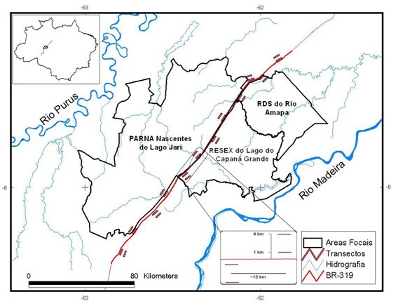
The region to be sampled in this study comprises three protected areas in Amazonas State, located in the area between the Purus and Madeira rivers, along 180 km of the BR-319 highway and surrounding areas.
Twenty-four 4-kilometer transects will be set up, distributed on terra firme forest along BR-319. Four pairs of transects will be created in each of the different protection categories: within the Integral Protection UCs Sustainable Use and outside each protected area. Each pair will be formed by a transect one kilometer away from the road and a second one four kilometers away. Each transect will be sampled for twenty days, once a year for three years. In each field campaign, two pairs of transects will be sampled simultaneously. Camera traps will be set up in each transect and surveys conducted during the day. Medium- and large-sized mammal surveys will also be carried out in 30-kilometers blocks on a 180-kilometer tract of BR-319.
This study aims to establish the null hypothesis of mammal abundance natural variation, so that in the future we can monitor and evaluate the impacts of repaving BR-319 through a BACI (Before-After Control Intervention) program.